On a day when the weather forecast predicted showers, possible sunny periods and strong winds Catherine and Kasher decided to do some light waymarking between Lower Ashes and Great Rock. Firstly, however, we decided to investigate a report of a drainage issue on Moor Lane off Lumbutts Road, adjacent to Top of the Rough (FP Tod 128).
 |
| 2. A small drainage channel created and turnby cleared. |
 |
| 1. The track (downhill view). |
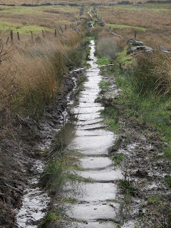
Unfortunately, the investigation of this drainage problem took all of the morning session! This causey path has long had a problem with water gushing off the hills above, and down the track to Top of the Rough . . . and beyond! Today, the causey stones were under water, the ditches were blocked and the turnbys silted up. It was certainly a track to avoid!
 |
| 4. Turnbys created to get the water into the drainage ditch. |
 |
| 3. Catherine clearing ditches. |
This was a day when a mattock (or two) would have been useful .... but not something we had packed for a day of waymarking! However, with Azad's and spades we managed to clear some of the ditches and to create other channels to divert the water away from the causey stones. We cleared and opened up the turnbys to get the water flowing to the side of the track and into the field drains.
 |
| 5. The water is now off the causey stones. |
The path is still very wet and slippery but with the water now diverted, the stone surface will soon dry ... given a little sunshine! This path and the associated ditches will need regular attention - water does tend to find its way back. However, as picture 5 shows, at the moment it is certainly drier and less slippery.
Today's work was funded by individual donations to CROWS. Many thanks.